12.0 Aquifer Protection District
12.1 Purpose.
Pursuant to NH RSA 674:16 and 674:21, the Aquifer Protection District is hereby established for the purposes of protecting, preserving and maintaining the existing and future municipal water supply sources of the Town of Wilton by regulating the uses of land over known aquifers and their recharge areas, so as to protect such supplies from contamination caused by adverse or incompatible land use practices or developments. The Aquifer Protection Ordinance is intended to limit the uses of land so designated to those which will not adversely affect water quality by contamination, or water quantity by preventing recharge of the aquifer.
12.2 District Location.
The boundaries of the Aquifer Protection District shall be the outermost edge of the surficial extent of all aquifer deposits presently designated as stratified drift as supported by information included in the USGS Aquifer Delineation study entitled Hydrogeology of Stratified Drift Aquifers and Water Quality in the Nashua Regional Planning Commission Area, South-Central, New Hampshire by K. W. Toppin, (1987), extended to include the boundaries of the Wellhead Protection District described in the following section. The Aquifer Protection District is a zoning overlay district which imposes additional requirements and restrictions to those of the underlying, base district zoning. In all cases, the more restrictive requirement(s) and permitted uses shall apply.
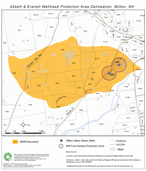
Wellhead Protection Area. The boundaries of the Wellhead Protection Area (WHPA) are as delineated in “WHPA Delineation – Abbott and Everett Production Wells Wilton, NH” by Emery and Garrett Groundwater, Inc (EGGI), 2008. See Figure 12.1 below. The map in Figure 12.1 was produced by Nashua Regional Planning Commission (NRPC) utilizing electronic “shape files” provided by EGGI, and depicts the revised WHPA. The EGGI study has increased the WHPA that was delineated in “The Wilton, N.H. Wellhead Protection Pilot Project” by Douglas L. Heath, October 1993; from 304 acres to 396 acres.
The limits of the combined WHPA in Figure 12.1 below are not surveyed, and therefore are approximate. For planning purposes, the Planning Board may use the EGGI revised WHPA boundary depicted below or as presented in the EGGI report cited above. (Amended March, 2007); (Amended March, 2009)
Figure 12–1
12.3 Permitted Uses.
The following uses shall be permitted in this district:
- industrial or commercial uses, in the appropriate District, which discharge no non-human wastes on site and human wastes only in an approved septic systems;
- industrial uses that discharge only non-contact cooling water;
- residential development under the following conditions:
- if serviced by Town water and sewer, at densities permitted in the underlying district;
- if serviced by on-site water and/or sewer, at fifty (50) percent of the density of the underlying District (i.e. double the acreage requirement of the underlying District); however, this does not increase the minimum dry area requirement of the underlying District;
- if developed under the Alternative Lot Requirements set forth in Section 6.3, the area of the reduced frontage lot does not have to be increased;
- areas located in the Watershed District at the density of the underlying district;
- activities designed for conservation of soil, water, plants, and wildlife;
- outdoor recreation, nature study, boating, fishing, and hunting where otherwise legally permitted;
- normal operation and maintenance of existing water bodies, wells, and dams, splash boards, weirs, and other water control, supply, and conservation devices;
- foot, bicycle, and/or horse paths and bridges;
- maintenance and repair of any existing structure; and
- farming, gardening, nursery, forestry, harvesting and grazing provided that fertilizers, herbicides, pesticides, manure, and other leachables are used appropriately and not stored outdoors in accordance with the following:
- the cultivation and harvesting of crops shall be performed in accordance with the recognized soil conservation practices of the Hillsborough County Conservation District and agricultural practices as may be regulated by the New Hampshire Department of Agriculture, the Division of Public Health Services of the Department of Health and Human Services, and the New Hampshire Water Supply and Pollution Control Division or as recommended by the Hillsborough County Extension Service;
- forestry or tree farming shall be performed in accordance with recognized management practices in order to protect the aquifer from contamination or damage as may be regulated by the Division of Forests and Lands of the New Hampshire Department of Resources and Economic Development or recommended by the Hillsborough County Soil Conservation District and Extension Service.
- Subsurface storage of propane/liquefied natural gas. (Adopted March 2004.)
12.4 Prohibited Uses.
The following uses shall not be permitted in the Aquifer Protection District:
- disposal of solid waste other than brush or stumps;
- Subsurface storage of regulated substances, including gasoline, diesel fuel, oil and other refined petroleum products, and the subsurface transmission of regulated substances, including gasoline, diesel fuel, oil and other refined petroleum products through pipelines;
- Disposal of liquid or leachable non-human wastes;
- Industrial or commercial uses which discharge contact type process waters on site; (Amended March 2004.);
- Outside, unenclosed storage of road salt;
- Dumping of snow containing de-icing chemicals brought from outside the Aquifer Protection District;
- Commercial animal feed-lots where animals are kept at excessive densities;
- Mining of land except incidental to a permitted use;
- Excavation(s) of sand or gravel, except those conducted in accordance with an approved Excavation Permit issued pursuant to the Excavation Regulations of the Town. Within the Wellhead Protection Area (WHPA), excavations of sand and gravel are subject to the following additional restrictions: (Amended March, 2007)
- Minimum depth to groundwater is ten (10) Feet.
- Crushing and or washing of materials is prohibited unless approval is granted by the Wilton Planning Board upon consultation with the Wilton Water Department and demonstration by the applicant that the proposed crushing or washing of materials will not adversely impact the water resource that is the subject of the Wellhead Protection Area.
- Storage of liquid petroleum products or other hazardous materials is prohibited.
- Storage of equipment or vehicles is prohibited, except in a manner designed to eliminate the danger of contamination due to leakage.
- Maintenance of vehicles is prohibited.
- All vehicles and equipment shall utilize biodegradable, non-hazardous hydraulic fluid and such other biodegradable and non-hazardous fluids as may be commercially available. Exceptions for short-term activity are solely at the discretion of the Planning Board on a case-by-case basis based on the potential risk to the aquifer and water supply.
- All on site handling, disposal, storage, processing or recycling of hazardous or toxic materials;
- Automotive service and repair shops, and junk and salvage yards unless they are operated in accordance with New Hampshire State statutes, rules and regulations governing such uses; and
- Bulk storage of toxic material for resale or distribution.
- New large groundwater withdrawals within four-thousand (4,000) feet of the Wellhead Protection Area defined in this section, except as preempted by state statute. If permitted by state statute, the Town of Wilton, NH hereby requires any and all optional requirements, including, but not limited to “Pre-Testing Conference and Revised Withdrawal Testing Design. (Adopted March, 2007)
- Any new or expansion of a use or activity, within the WHPA defined above, listed in the NH Groundwater Protection Act list of Potential Contamination Sources (PCSs), as defined in RSA 485-C. (Adopted March, 2007)
- The siting or operation of a wastewater or septage lagoon within the WHPA or Aquifer district. (Adopted March, 2007)
12.5 Performance Standards.
All subdivision proposals and other proposed new developments within the Aquifer Protection District shall be reviewed by the Planning Board and shall conform to the provisions of this ordinance, the Subdivision Regulations of the Town of Wilton and the following:
- All such proposals are consistent with the need to protect the groundwater of the Town of Wilton and adjacent communities.
- All sanitary sewer systems are designed to minimize or eliminate leakage or discharges from the system into the groundwater.
- On site waste disposal systems are located so as to avoid or minimize groundwater contamination.
- All surface storm water generated by development is kept on-site and handled in such a manner as to allow the water to infiltrate into the ground before leaving the site.
- Streets, roads, and parking areas are constructed so that the need for direct application of road salt is minimized for winter safety, and so that run-off from such uses is channeled to avoid or minimize groundwater contamination.
- Written approval of the State of New Hampshire Department of Environmental Services, Water Supply and Pollution Control Division for subdivision and septic systems has been obtained.
- Under the NH Groundwater Protection Act, existing uses or activities, within the WHPA, listed in RSA 485-C as Potential Contamination Sources (PCSs) shall follow Best Management Practices (BMPs) for Groundwater Protection as adopted under the NH Code of Administrative Rules Part ENV-Ws 421, Best Management Practices. (Adopted March, 2007)
12.6 Incorrectly Designated Zones.
When the actual boundary of the Aquifer Protection District is in dispute by any owner or abutter actually affected by the boundary, the Planning Board, at the owner/abutters expense and request, may engage a professional geologist or hydrologist to determine more accurately the precise boundary of the Aquifer Protection District, who shall submit to the Planning Board his findings, including:
- a detailed topographic layout of the subdivision and/or area to be developed, prepared by a registered land surveyor;
- a revised soils map of the subdivision and/or area prepared by a certified soil scientist qualified in hydrologic studies including a written report of his on-site field inspection and test boring data;
- the aquifer boundary as shown on the U.S. Geological Survey Map shall be overlaid on the plat and the newly proposed boundary location shall be indicated on the same plat by a broken line; and
- any additional mapping, hydrogeologic reports or information which becomes available, as a result of recent or on-going scientific investigation of the location and extent of aquifers, performed by the U.S. Geological Survey, New Hampshire State agencies or boards, the Town of Wilton or the agents of any of the above.
The Planning Board, based upon the findings presented by the applicant, may adjust the boundary or area designation of the Aquifer Protection District to reduce or expand the designated area to more correctly define the location and extent of the aquifer on a site-specific, case-by-case basis.
The Planning Board shall reserve the right to withhold action on the plat pending the results of an on-site and/or other investigation by the Board or its appointed agent and shall act to approve or disapprove the final plat within 65 days of submission or such further time as deemed necessary and as provided for by New Hampshire State statute as amended (Amended March 2018).
12.7 Non-Conforming Uses.
Non-conforming uses may continue in this district in the form in which they exist at the time of the adoption of this ordinance unless they pose a direct hazard to the aquifer or are actually introducing some foreign substances (oils, salts, chemicals, etc.) into the aquifer. In the latter case, the Selectmen shall issue an immediate cease and desist order to stop the offending activity or process from continuing activity in this district.